Ghost Towns
South Pittsburg Historic Preservation Society
Preservation through Determination
Insuring a Place in the Future for Our Heritage!

Rexton, Tennessee
Rexton, Tennessee

  By Dennis Lambert
  February 2006

   In early 1909, investors, led in part by Ringland Fisher “Rex” Kilpatrick of New York, purchased land at the head of King’s Cove, which itself is mostly located in Alabama near Bridgeport. Spurred on by the success of the coal mining operations in the neighboring coves of Doran’s Cove and Sweeden’s Cove and what was known as the Battle Creek coal seam, Kilpatrick and investors believed after extensive surveys that this profitable seam extended into King’s Cove.

    This land was once mined several years before less extensively in what was known as the old R. A. Patton and Gaines coal lands. This moderate success of the previous mining operations and the positive report from the surveys soon led to the establishment of the Tennessee River Coal Company. 
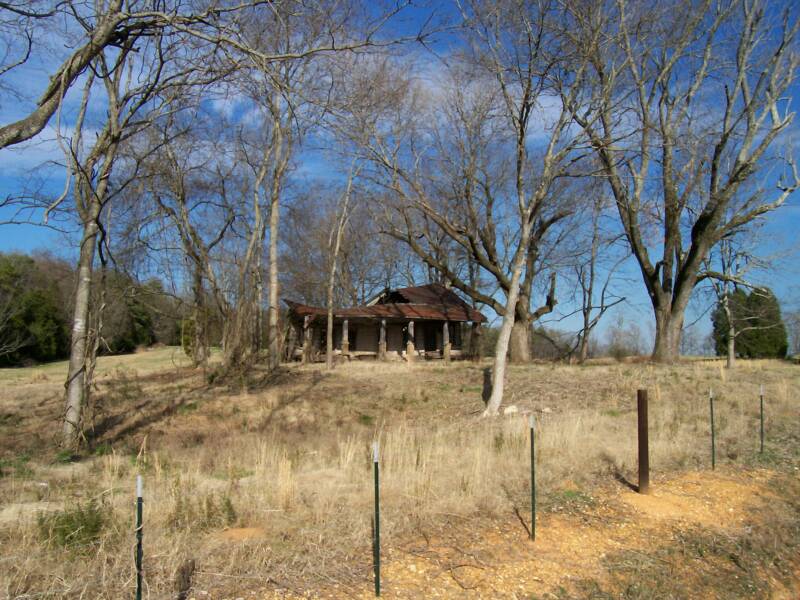
This old home on the road leading into King's Cove in northeast Alabama near Bridgeport, is a reminder of the rich history of the cove.
Photograph by Dennis Lambert - January 28, 2006Photograph by Dennis Lambert - January 28, 2006
Photograph by Dennis Lambert - January 28, 2006Photograph by Dennis Lambert - January 28, 2006Photograph by Dennis Lambert - January 28, 2006
Photograph by Dennis Lambert - January 28, 2006Photograph by Dennis Lambert - January 28, 2006Photograph by Dennis Lambert - January 28, 2006Photograph by Dennis Lambert - January 28, 2006
Photograph by Dennis Lambert - January 28, 2006Photograph by Dennis Lambert - January 28, 2006Photograph by Dennis Lambert - January 28, 2006
Photograph by Dennis Lambert - January 28, 2006Photograph by Dennis Lambert - January 28, 2006
Photograph by Dennis Lambert - January 28, 2006
Photograph by Dennis Lambert - January 28, 2006Photograph by Dennis Lambert - January 28, 2006
SPHPSInc
    This company had intentions of mining this coal and shipping it out to market by way of an extension railroad that would lead off the Dixie-Portland cement plant’s extension, which itself led off from the Pikeville Branch Railroad in Copenhagen (Richard City), Tennessee. In addition was the company’s plan to establish a permanent community near the mines, which would be named Rexton in honor of the primary investor, Mr. Kilpatrick.

    Offices for the new company were established on the second floor of the First National Bank building in South Pittsburg. In addition, contractors R. A & B. F. Patton, builders of the mining town, also opened their offices in the bank building.


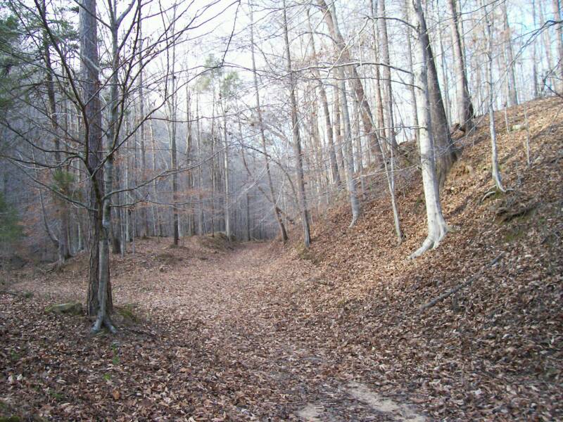
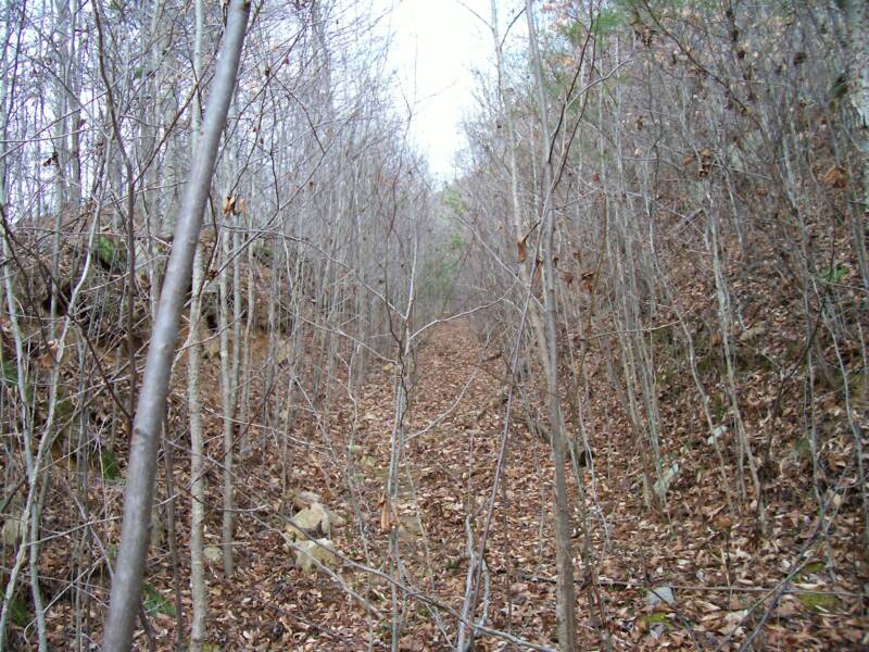
This old farm road in King's Cove follows closely the original railroad bed that led into Rexton, Tennessee. Located on the farm of Harold Grider, most of the old rail bed is visible. Rexton is located about two miles farther back from this point.    
Photograph by Dennis Lambert - January 28, 2006Photograph by Dennis Lambert - January 28, 2006
Photograph by Dennis Lambert - January 28, 2006Photograph by Dennis Lambert - January 28, 2006Photograph by Dennis Lambert - January 28, 2006
Photograph by Dennis Lambert - January 28, 2006Photograph by Dennis Lambert - January 28, 2006Photograph by Dennis Lambert - January 28, 2006Photograph by Dennis Lambert - January 28, 2006
Photograph by Dennis Lambert - January 28, 2006Photograph by Dennis Lambert - January 28, 2006Photograph by Dennis Lambert - January 28, 2006
Photograph by Dennis Lambert - January 28, 2006Photograph by Dennis Lambert - January 28, 2006
Photograph by Dennis Lambert - January 28, 2006
Photograph by Dennis Lambert - January 28, 2006Photograph by Dennis Lambert - January 28, 2006
SPHPSInc
   Right of way agreements were soon purchased or secured from property owners including one for a wagon road and another for water rights from John Berry Wynne on September 30, 1909.

   On October 6, 1909, ground was broken at the company’s King’s Cove town site for the five-mile long railroad leading from Richard City into King’s Cove. Contracted to do the work were local contractors R. A. & B. F. Patton and J. N. Dietzen who wasted no time in getting supplies and tools on the ground in preparation for the railroad’s construction.
 
Photograph by Dennis Lambert - January 28, 2006Photograph by Dennis Lambert - January 28, 2006
Photograph by Dennis Lambert - January 28, 2006Photograph by Dennis Lambert - January 28, 2006Photograph by Dennis Lambert - January 28, 2006
Photograph by Dennis Lambert - January 28, 2006Photograph by Dennis Lambert - January 28, 2006Photograph by Dennis Lambert - January 28, 2006Photograph by Dennis Lambert - January 28, 2006
Photograph by Dennis Lambert - January 28, 2006Photograph by Dennis Lambert - January 28, 2006Photograph by Dennis Lambert - January 28, 2006
Photograph by Dennis Lambert - January 28, 2006Photograph by Dennis Lambert - January 28, 2006
Photograph by Dennis Lambert - January 28, 2006
Photograph by Dennis Lambert - January 28, 2006Photograph by Dennis Lambert - January 28, 2006
SPHPSInc
  Construction of the town site and entries into the mines were under the direction of engineer, Captain George W. Crozier, with this phase of construction starting earlier in 1909. By January 1910, work on Rexton was progressing rapidly with completion expected by spring. In the town itself, which was situated on the mountain, a nineteen-room hotel, seven-room office building, two-story store building and nearly 35-three and four room worker’s cottages were in the throws of being completed.
 
Here the original railroad bed that led into Rexton, Tennessee can easily be seen as it cut through the slope of the hillside.  
    Delays due to weather slowed construction in early March due to the poor conditions of the wagon roads making it nearly impossible to move supplies into the cove. The railroad from Copenhagen had already been completed as far as Clayton Jenkins’ residence with completion to the mines expected as soon as the weather broke and conditions improved. Once completed, the railroad would speed up construction bringing completion of the works in King’s Cove rapidly. The town was incorporated on October 31, 1910.

    However, not long after the completion of construction of the railroad and town, it was discovered the prospects of a large coal vein in Rexton did not play out as investors first thought would be the case. The coal vein was discovered to be much thinner once entries were made. Further mining failed to produce enough coal to recoup the investments made in the region. By 1912, investors abandoned Rexton, Tennessee along with its mines.
 
    One likely factor in the abandonment of Rexton is that the railroad into King’s Cove was partly washed out in a flash flood. This, combined with the death of Rex’s father, Frank J. Kilpatrick, in New York City on November 4, 1911, would have demoralized the chief investor.

    It appears from visits to the site that some of the investment was recouped through the salvage of materials at Rexton as little remains to mark the ghost town. It could be as well that farmers living in the cove removed lumber and other materials for use on their farms. Either way, many rock foundations and sections of the railroad bed along with bridge abutments still stand in the cove.

    This property is privately owned so please contact the landowner before attempting a visit to the ruins. 

    One item to note is Rex’s father, Frank J. Kilpatrick. He and his brother, Walter F. Kilpatrick, were the primary investors in the Bridgeport, Alabama boom of 1888 to 1893.
Photograph by Dennis Lambert - January 28, 2006Photograph by Dennis Lambert - January 28, 2006
Photograph by Dennis Lambert - January 28, 2006Photograph by Dennis Lambert - January 28, 2006Photograph by Dennis Lambert - January 28, 2006
Photograph by Dennis Lambert - January 28, 2006Photograph by Dennis Lambert - January 28, 2006Photograph by Dennis Lambert - January 28, 2006Photograph by Dennis Lambert - January 28, 2006
Photograph by Dennis Lambert - January 28, 2006Photograph by Dennis Lambert - January 28, 2006Photograph by Dennis Lambert - January 28, 2006
Photograph by Dennis Lambert - January 28, 2006Photograph by Dennis Lambert - January 28, 2006
Photograph by Dennis Lambert - January 28, 2006
Photograph by Dennis Lambert - January 28, 2006Photograph by Dennis Lambert - January 28, 2006
SPHPSInc
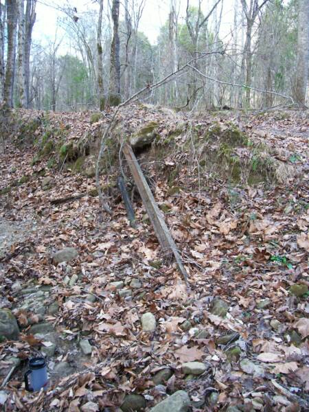
Pictured here is an original section of the rail from the railroad that led into Rexton, Tennessee.  
    Bridgeport was another shattered Kilpatrick dream as Rex’s father and uncle invested heavily into Bridgeport boom period growth in hopes that it would become the New York City of the South. However, the economic “Panic of 1893” put an end to that dream. Many reminders of that dream including a group of “Queen Anne” homes built by Frank J., which are known as "Kilpatrick Row", still stand as a testament to that lost dream.  
SPHPSInc
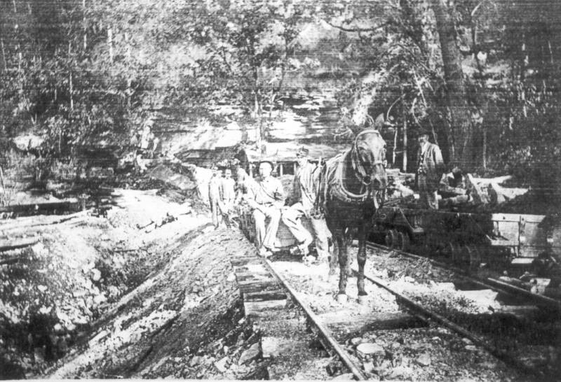
Pictured here is the only known picture showing the coal mines in Rexton during operation. This picture was made about 1911 and shows the horse pulling the coal car from the mine for transport down the incline to the tipple.

                                                                 Photograph Courtesy, Noni Webb  
Photograph by Dennis Lambert - January 28, 2006Photograph by Dennis Lambert - January 28, 2006
Photograph by Dennis Lambert - January 28, 2006Photograph by Dennis Lambert - January 28, 2006Photograph by Dennis Lambert - January 28, 2006
Photograph by Dennis Lambert - January 28, 2006Photograph by Dennis Lambert - January 28, 2006Photograph by Dennis Lambert - January 28, 2006Photograph by Dennis Lambert - January 28, 2006
Photograph by Dennis Lambert - January 28, 2006Photograph by Dennis Lambert - January 28, 2006Photograph by Dennis Lambert - January 28, 2006
Photograph by Dennis Lambert - January 28, 2006Photograph by Dennis Lambert - January 28, 2006
Photograph by Dennis Lambert - January 28, 2006
Photograph by Dennis Lambert - January 28, 2006Photograph by Dennis Lambert - January 28, 2006
Photograph by Dennis Lambert - January 28, 2006Photograph by Dennis Lambert - January 28, 2006Photograph by Dennis Lambert - January 28, 2006
Photograph by Dennis Lambert - January 28, 2006Photograph by Dennis Lambert - January 28, 2006Photograph by Dennis Lambert - January 28, 2006Photograph by Dennis Lambert - January 28, 2006
Photograph by Dennis Lambert - January 28, 2006Photograph by Dennis Lambert - January 28, 2006Photograph by Dennis Lambert - January 28, 2006
Photograph by Dennis Lambert - January 28, 2006Photograph by Dennis Lambert - January 28, 2006
Photograph by Dennis Lambert - January 28, 2006
Photograph by Dennis Lambert - January 28, 2006Photograph by Dennis Lambert - January 28, 2006
SPHPSInc
SPHPSInc
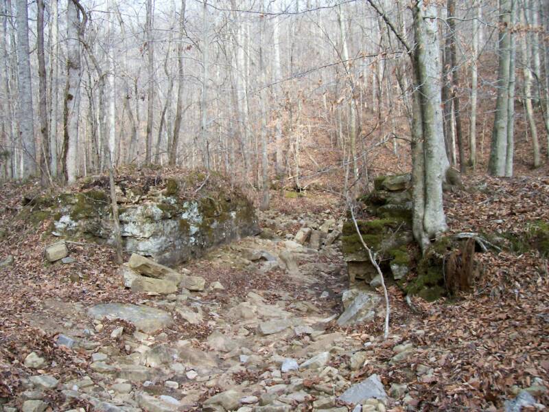
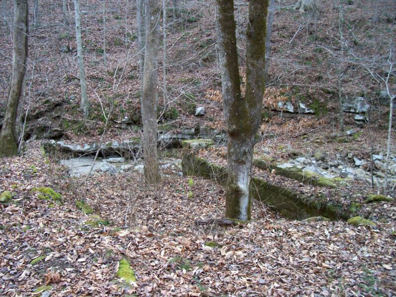
In the two pictures above can be seen different views of a pair of bridge abutments for the Rexton Railroad. Made of hand-hewn sandstone and limestone blocks, the abutments stand about eight feet tall. 
Photograph by Dennis Lambert - January 28, 2006Photograph by Dennis Lambert - January 28, 2006
Photograph by Dennis Lambert - January 28, 2006Photograph by Dennis Lambert - January 28, 2006Photograph by Dennis Lambert - January 28, 2006
Photograph by Dennis Lambert - January 28, 2006Photograph by Dennis Lambert - January 28, 2006Photograph by Dennis Lambert - January 28, 2006Photograph by Dennis Lambert - January 28, 2006
Photograph by Dennis Lambert - January 28, 2006Photograph by Dennis Lambert - January 28, 2006Photograph by Dennis Lambert - January 28, 2006
Photograph by Dennis Lambert - January 28, 2006Photograph by Dennis Lambert - January 28, 2006
Photograph by Dennis Lambert - January 28, 2006
Photograph by Dennis Lambert - January 28, 2006Photograph by Dennis Lambert - January 28, 2006
SPHPSInc
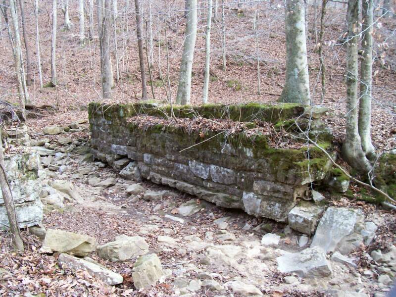
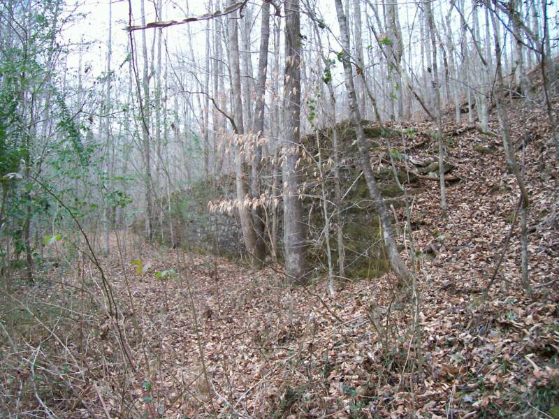
In the picture above can be seen a stone retainer wall above the old railroad bed. This wall is about one-hundred fifty feet long and stands about ten feet high. 
Photograph by Dennis Lambert - January 28, 2006Photograph by Dennis Lambert - January 28, 2006
Photograph by Dennis Lambert - January 28, 2006Photograph by Dennis Lambert - January 28, 2006Photograph by Dennis Lambert - January 28, 2006
Photograph by Dennis Lambert - January 28, 2006Photograph by Dennis Lambert - January 28, 2006Photograph by Dennis Lambert - January 28, 2006Photograph by Dennis Lambert - January 28, 2006
Photograph by Dennis Lambert - January 28, 2006Photograph by Dennis Lambert - January 28, 2006Photograph by Dennis Lambert - January 28, 2006
Photograph by Dennis Lambert - January 28, 2006Photograph by Dennis Lambert - January 28, 2006
Photograph by Dennis Lambert - January 28, 2006
Photograph by Dennis Lambert - January 28, 2006Photograph by Dennis Lambert - January 28, 2006
Photograph by Dennis Lambert - January 28, 2006Photograph by Dennis Lambert - January 28, 2006Photograph by Dennis Lambert - January 28, 2006
Photograph by Dennis Lambert - January 28, 2006Photograph by Dennis Lambert - January 28, 2006Photograph by Dennis Lambert - January 28, 2006Photograph by Dennis Lambert - January 28, 2006
Photograph by Dennis Lambert - January 28, 2006Photograph by Dennis Lambert - January 28, 2006Photograph by Dennis Lambert - January 28, 2006
Photograph by Dennis Lambert - January 28, 2006Photograph by Dennis Lambert - January 28, 2006
Photograph by Dennis Lambert - January 28, 2006
Photograph by Dennis Lambert - January 28, 2006Photograph by Dennis Lambert - January 28, 2006
SPHPSInc
SPHPSInc
In the two above pictures can be seen more ruins in Rexton, Tennessee. On the left is the concrete supports that once supported the coal tipple. On the right is another pair of railroad bridge abutments.
Photograph by Dennis Lambert - January 28, 2006Photograph by Dennis Lambert - January 28, 2006
Photograph by Dennis Lambert - January 28, 2006Photograph by Dennis Lambert - January 28, 2006Photograph by Dennis Lambert - January 28, 2006
Photograph by Dennis Lambert - January 28, 2006Photograph by Dennis Lambert - January 28, 2006Photograph by Dennis Lambert - January 28, 2006Photograph by Dennis Lambert - January 28, 2006
Photograph by Dennis Lambert - January 28, 2006Photograph by Dennis Lambert - January 28, 2006Photograph by Dennis Lambert - January 28, 2006
Photograph by Dennis Lambert - January 28, 2006Photograph by Dennis Lambert - January 28, 2006
Photograph by Dennis Lambert - January 28, 2006
Photograph by Dennis Lambert - January 28, 2006Photograph by Dennis Lambert - January 28, 2006
SPHPSInc
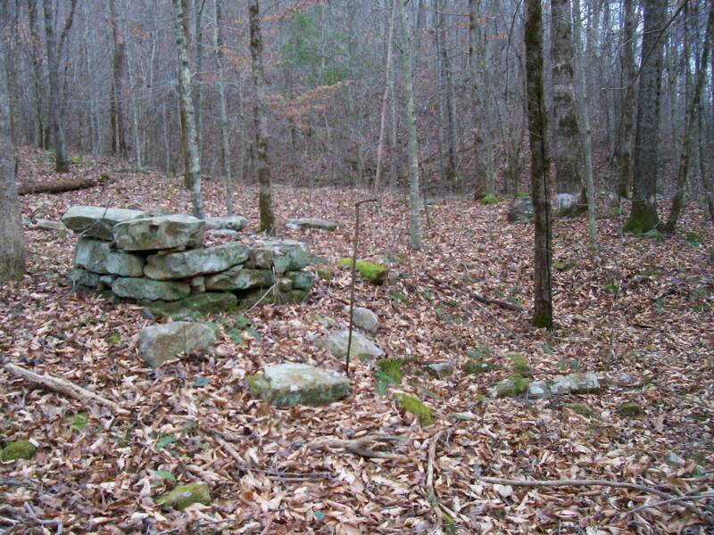
The picture above shows what remains where a small cabin once stood. The stone blocks were part of a chimney.
Photograph by Dennis Lambert - January 28, 2006Photograph by Dennis Lambert - January 28, 2006
Photograph by Dennis Lambert - January 28, 2006Photograph by Dennis Lambert - January 28, 2006Photograph by Dennis Lambert - January 28, 2006
Photograph by Dennis Lambert - January 28, 2006Photograph by Dennis Lambert - January 28, 2006Photograph by Dennis Lambert - January 28, 2006Photograph by Dennis Lambert - January 28, 2006
Photograph by Dennis Lambert - January 28, 2006Photograph by Dennis Lambert - January 28, 2006Photograph by Dennis Lambert - January 28, 2006
Photograph by Dennis Lambert - January 28, 2006Photograph by Dennis Lambert - January 28, 2006
Photograph by Dennis Lambert - January 28, 2006
Photograph by Dennis Lambert - January 28, 2006Photograph by Dennis Lambert - January 28, 2006
Photograph by Dennis Lambert - January 28, 2006Photograph by Dennis Lambert - January 28, 2006Photograph by Dennis Lambert - January 28, 2006
Photograph by Dennis Lambert - January 28, 2006Photograph by Dennis Lambert - January 28, 2006Photograph by Dennis Lambert - January 28, 2006Photograph by Dennis Lambert - January 28, 2006
Photograph by Dennis Lambert - January 28, 2006Photograph by Dennis Lambert - January 28, 2006Photograph by Dennis Lambert - January 28, 2006
Photograph by Dennis Lambert - January 28, 2006Photograph by Dennis Lambert - January 28, 2006
Photograph by Dennis Lambert - January 28, 2006
Photograph by Dennis Lambert - January 28, 2006Photograph by Dennis Lambert - January 28, 2006
SPHPSInc
SPHPSInc
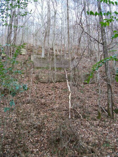
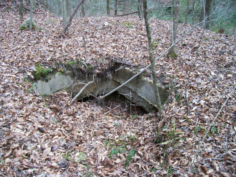
The above left picture shows an unknown concrete structure that appears to have been an underground storage unit. The picture on the right shows the old coal mine incline rail bed leading up the mountain side.
Photograph by Dennis Lambert - January 28, 2006Photograph by Dennis Lambert - January 28, 2006
Photograph by Dennis Lambert - January 28, 2006Photograph by Dennis Lambert - January 28, 2006Photograph by Dennis Lambert - January 28, 2006
Photograph by Dennis Lambert - January 28, 2006Photograph by Dennis Lambert - January 28, 2006Photograph by Dennis Lambert - January 28, 2006Photograph by Dennis Lambert - January 28, 2006
Photograph by Dennis Lambert - January 28, 2006Photograph by Dennis Lambert - January 28, 2006Photograph by Dennis Lambert - January 28, 2006
Photograph by Dennis Lambert - January 28, 2006Photograph by Dennis Lambert - January 28, 2006
Photograph by Dennis Lambert - January 28, 2006
Photograph by Dennis Lambert - January 28, 2006Photograph by Dennis Lambert - January 28, 2006
SPHPSInc
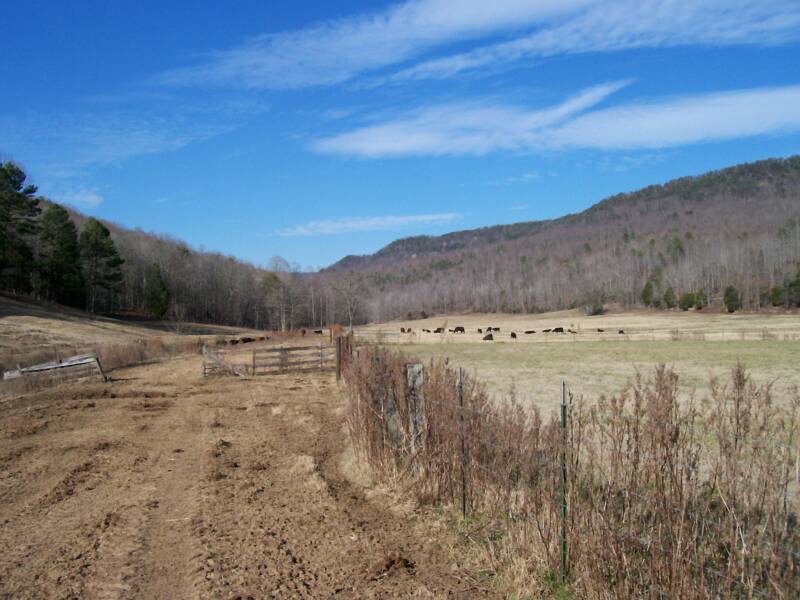
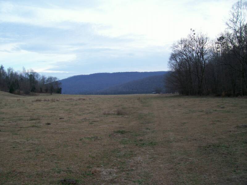
The above picture is looking back east towards Bridgeport out of King's Cove across the pastures of Mr. Grider. The road bed in the picture is the old railroad bed for the Rexton Railroad.

This page was built on February 15, 2006
SPHPSInc
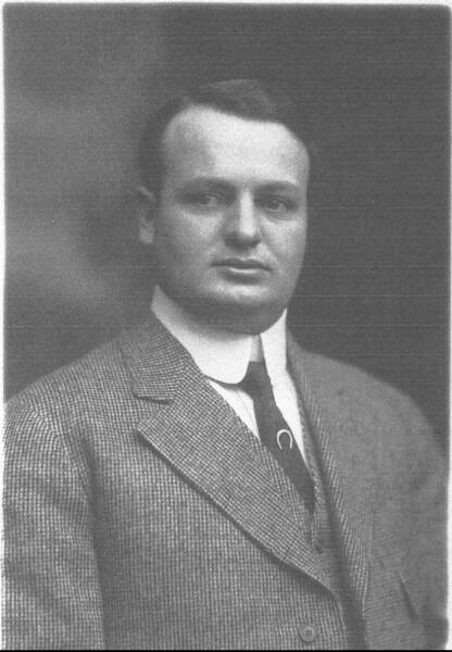
Ringland "Rex" Fisher Kilpatrick (1881-1955) pictured above was the primary investor in Rexton, Tennessee. The mining town was named in his honor.
  Photograph Courtesy, Rex K. Bray  
This page was last updated: June 26, 2007